The Indian Space Research Organisation (ISRO) and the National Aeronautics and Space Administration (NASA) have officially set the launch date for the NISAR mission—the NASA-ISRO Synthetic Aperture Radar satellite. This ground-breaking collaboration between the two space agencies is scheduled to lift off on July 30, 2025, at 5:40 PM IST (17:40 IST), utilizing ISRO’s GSLV-F16 from the Satish Dhawan Space Centre (SDSC SHAR) in Sriharikota, Andhra Pradesh. NISAR will be placed into a Sun-synchronous orbit (SSO) at an altitude of 743 km, with an inclination of 98.4 degrees. This nearly polar orbit ensures that the satellite passes over any specific point on Earth at the same solar time daily, providing consistent illumination crucial for imaging and other time-dependent tasks.
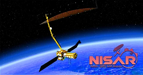
This state-of-the-art satellite will orbit the Earth, conducting comprehensive scans of the planet every 12 days, delivering high-resolution data regardless of weather conditions or time of day. Weighing in at 2,392 kg, NISAR stands out as a pioneering Earth observation satellite. It will be the first to deploy a dual-frequency Synthetic Aperture Radar system, featuring both NASA's L-band and ISRO's S-band frequencies. By employing two optimally defined radar systems, the mission aims to monitor a broader spectrum of Earth’s changes compared to using a single frequency. Equipped with NASA's 12-meter unfurlable mesh reflector antenna integrated into ISRO’s modified I3K satellite bus, NISAR will utilize advanced SweepSAR technology to capture vast areas of 242 km with high spatial resolution. This capability will enable the satellite to precisely measure changes in the Earth's surface, including ground deformation, ice sheet movement, and vegetation dynamics. According to NASA, NISAR will be capable of detecting movements as subtle as a few centimeters.
The satellite will conduct global scans, providing all-weather data day and night, with a revisit interval of 12 days. Its capabilities will not be hindered by cloud cover and will support applications such as:
Ø Sea ice classification
Ø Ship detection
Ø Shoreline monitoring
Ø Storm characterization
Ø Soil moisture changes
Ø Mapping and monitoring of surface water resources
Ø Disaster response
“NISAR's data can help people globally manage natural resources and hazards more effectively," stated NASA. "It will also furnish scientists with crucial information to deepen understanding of climate change impacts and trends.”
The mission aims to enhance comprehension of the Earth’s crust, with NISAR's data offering insights into phenomena such as earthquakes, volcanoes, and landslides, along with their effects on infrastructure. The NISAR mission represents a significant collaboration between NASA and ISRO, marking their first hardware partnership. NASA contributes radar systems, communication technologies, and scientific instruments, while ISRO supplies the spacecraft, launch vehicle, and operational support. The project is managed by Caltech, with the Jet Propulsion Laboratory leading the U.S. side, while India’s contributions are overseen by the UR Rao Satellite Centre in Bengaluru and the ISRO Space Applications Centre in Ahmedabad.